Revisiting the past country

I grew up in Tasmania. I am not however a Tasmanian, having not been born there nor having any family connections - this is an important distinction; perhaps more so during my childhood when Tasmanian parochialism was only outshone by Hobart vs Launceston rivalry, or Burnie vs Devonport, or Queenstown vs the entire universe. I left in the early 1980s and only rarely go back to visit a sister who still lives there. For the first time in about 30 years, I went there during summer.

What continually astonishes me is the myriad of variations on landscape, ecosystems, light, colour, twilight, shadow each small locale throws up. The first three photos are from Low Head, which is on the eastern mouth of the Tamar, on the seaward side facing Bass Strait. Although the Strait is rightly respected as a treacherous stretch of water, its colours and nature where it makes its littoral shores from Woolnorth to Cape Portland in the east is grey, mauve, so often leaden light, tufts of shore grass leaning in the wind. Perhaps because the clouds hang low, there is a sense of human scale to much of that maritime landscape.

Perhaps even English or British. I had forgotten that Tasmania is home to a gull, Larus pacificus, that is much larger than the silver gull that patrols every town tip from Bega to Alice Springs. The Pacific gull meows, something close to the crying of gulls in English ports; always an aural shock in that first hearing, more reserved than the incessant screeching of silver gulls. Dotterels, plovers, oyster catchers run on the rocks and beaches; clinker built wooden dinghies lie above the high tide mark, half buried in the shore grass. Low Head also has a number of small shingle beaches to the north of the main beach, where basalt flows make small headlands, crisscrossed by the rusting wire fences of those who believe they own the land.

Rosevears sits on the Tamar, about half way between Launceston and its mouth at Low Head. There is a pub that sits in the crook of the road looking upriver to Gravelly Beach or across the estuary to Windermere on the opposite shore. After a couple of visits you learn not to try and sit to snatch the whole view of the river but to frame a smaller portion, to savour the light, the pulse and beat of the river, the wind on the water and grasses, the hum of farming in the small fields that roll into the road and the river.

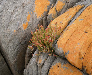
Binalong Bay sits east of St Helens, a fishing village turned retirement mecca itself at the end of Georges Bay. Binalong was originally known as Boat Harbour, an odd name for a series of rocky gulchs that would have required the luck of the devil to sail into during dirty weather. It's now marketed as part of the moniker Bay of Fires which covers a stretch of coast from Binalong in the south to Eddystone Point in the north. Blinding white sand stretch out into waters that hold their blue even when it rains, broken by granite outcrops stained with lurid orange lichens. Much of the hillsides folding down to the beaches are still clothed in dry sclerophyll forests, interspersed with casuarina micro-forests, lagoons and creeks.

I walked from the northern end of Cosy Corner back to Binalong one morning, and in the glare of a summer sun remembered my first trip to the area at 15 just as my parents were looking at buying a home in St Helens. Sitting in the family car near the shops, the back streets lined with red flowering gums, Corymbia ficifolia, towering eucalypts down the main street, pastures flat to the bowl of the bay, weather beaten wooden fences leaning out of the grass, the push and puff of a sea breeze, and all the while the boats in motion at anchor, current and tide tugging like children, wanting to pull them away. I had forgotten how visceral these landscapes are. How impossibly beautiful. How beautiful still.
Sigh.
ReplyDelete